Review of GeoControl
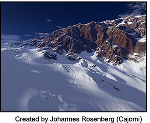
GeoControl is an independent stand-alone terrain creation program created by Johannes Rosenberg (Cajomi). I am going to start this review in a very different manner. I first want to state how great the documentation is for GeoControl. I worked with the program a short while before the final version and never really understood some of the concepts and terminology behind it; for example, what was meant by Levels. Much of the documentation was still only in German. Those who know the program will understand what I mean and those who don't, I hope, will get to know it in the future. Understanding Dynamic Level Generation is very helpful in working with GeoControl. Even though I had researched the terminology on the web, it was not until I read Johannes' (Cajomi's) explanation did the concept become clear and did my working with GeoControl fall into place. His documentation is precise, explicit, and complete.
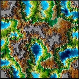
I guess pictures can speak louder than words. Here is my first terrain, created in GeoControl from a preset which I modified a little with the brush tool. I wanted to see how it would look "test" rendered in GeoControl and then imported into Vue 5 Infinite without any modifications except positioning. Below is the GeoControl terrain in 2D.
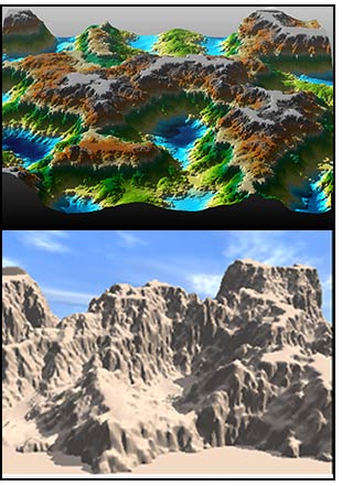
Next is the "test" rendered 3D version (top view) and the terrain in Vue 5 Infinite (below it).
I will, now, describe how GeoControl works. Let me start by saying that the terrains can vary in size from 64 x 64 pixels to 4096 x 4096 pixels. One can start with a blank terrain, one of the many presets created by Cajomi and others, or the random preset that appears when GeoControl is accessed. In its 2D form it can look similar to the first illustration above. One can also see it in black and white, simple gray, or Red Mesa. One can also choose the level of relief - from no relief to very rough.
On the right side of the screen are three panels. The Terrain Panel is the one from which one basically starts creating the terrain.
This panel also contains the Brush Tool which is square in shape and specialized. You will notice the words - Brush Settings and Brush Size. This tool works with filters to modify the terrain at different levels. It also can be used to create a terrain from scratch. Basically one works from the lowest or coarsest level to the highest or finest level.
The next panel is the Terrain Shape Panel. This panel also comes with presets if desired.
Here, one is adding filters to refine the terrain. With GeoControl, one does not work per se on the finished level. One works on various levels and can control which levels can be changed, which cannot, and by what strength. This gives the user tremendous control.
The third panel is the Project Panel. Using this panel, one can save one's work as a project and can create various layers in the project. These layers can, then, be blended together using adding, subtracting, various types of averaging, etc.
There are many ways one can go about using GeoControl. As with any program, the more familiar one is with it, the more one can control it. However, it is also just fun to build terrains and see how they eventually develop. To see some masters at work, look at the Gallery on the GeoControl forum. There, one will see some very intricate terrains that have been rendered in various landscape programs such as Vue, Carrara, Terragen, Bryce, and others. GeoControl imports and exports terrains to and from many file formats.
These master artists (and master is the title I have given them) have also created many presets for people to use in GeoControl by themselves or as a base for creating other landscapes. These are also a wonderful way to learn about the capabilities of GeoControl.
What is also so unique about GeoControl is that while it will work with all the landscape programs mentioned above, one will probably find the program that one enjoys using it with the most and will find that they can, then, tailor their terrains that they will generate for that program.
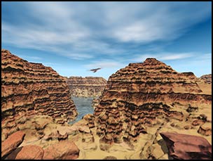
One can also "mix and match." By this I mean, one can build more than one landscape in GeoControl for a scene in Vue, for example, and, also use terrains from Vue. In the scene below, I have identified which terrains I build in which program. I chose the program that gave me the exact control I needed for my idea. I, also, found that I could build a few potential terrains in GeoControl and then choose which section of the large terrain I wanted to specifically use.
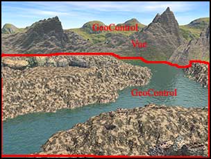
Could I possibly have built the whole landscape in Vue 5 Infinite? Yes. But, I was able to control the rolling hills exactly as I wanted them to appear as well as place the river in the canyon perfectly and control the flat top of the furthest canyon. This is a very simple and easy use of GeoControl; it is one that a novice can do very easily.
Below is an image using a full terrain created initially in GeoControl and, then, finished and rendered in Vue 5 Infinite.
I was very impressed that with this new program I only found one bug. I was even more impressed that when I hit the error, a message popped up and asked me would I like to report the message and should I continue or stop the program. I reported the message, and within two hours, Cajomi had thanked me for reporting it and explained that he wanted to catch any errors that had slipped through the intensive testing. I knew he was not doing this because I was a reviewer because I have seen how he answers posts in his forum and in other forums with the same amount of courtesy and responsibility to his users.
GeoControl has its own forum that provides all the help one needs. The web site is: http://www.cajomi.de/GeoControl/geocontrol.htm. One can download a demo version of GeoControl or purchase it from the same place.
There is an introductory price of 49 Euro which is about $63 and will be good until 22.05.2006. Then it will be 59 Euro and about $76.
Do I like the product? Absolutely. Do I recommend it? Absolutely. What is also important is that it is a lot of fun to use.
![]()